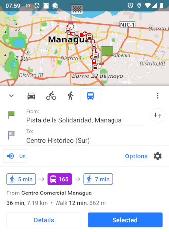
Most cities of the world with public transportation don’t have a map of it!
Or to be precise: a World Bank study estimates that 35% of the world’s largest cities and even 92% when considering only the largest cities in low- and middle-income countries do not have complete transit maps for planning or passenger information.
But this is changing!
There are ongoing initiatives around public transport for international development: Digital Transport 4 Africa, Resource center on digital transport for Latin America, Transformative Urban Mobility Initiative, WRI Sustainable Cities and more. These are also addressing the political and encouraging aspects of supporting local governments and working for sustainable development. Many cities all over the world cooperate with such initiatives and they are building their technical solutions right now.
In addition, Open Data communities of practice are emerging everywhere. Start-ups, universities and individuals are using the digital commons like OpenStreetMap to collect data about their city and its public transportation network. In a similar way to how paratransit emerges, the data about public transport in OpenStreetMap is growing in an uncoordinated way, but based on the need, vision and entrepreneurship of people and empowered citizens.
Of course there are technical challenges.
There is an often underestimated complexity in managing public transport data successfully and providing useful services around it. This starts with mapping and collecting data on public transport networks, then converting the data, but also keeping the data up to date, and of course setting up and managing the technical infrastructure to ultimately make the data available as or in usable products for the passengers.
It is important to realize that routing (how to get from a to b) using schedule-based public transportation is mathematically much more complex than pedestrian, bike or car routing. This is the reason why most transit applications only work online, and why city administrations in the global south struggle to build up IT departments to maintain software and host complex routing servers.
An interesting approach has been taken by the application Maps.me, which is one of the first of its kind to offer offline routing of metro lines, based on OpenStreetMap data in selected larger cities. In order to reduce and therefore manage the complexity, they calculate the routing without schedules and time information, which is acceptable for metro lines that run periodically.
Usually, cities without data and information on their public transport network tend to be more diverse in how public transport works. This is often called artisan transport or paratransit, where public transport systems emerge based on the needs of the population and the influence of bus owners, local authorities and physical conditions. In these cities, a meticulously defined schedule is not present, and time-less routing is an option, too - at least as the very first but important step of having any information at all.
And the simplest solution.
Just recently, OpenStreetMap’s most classical Android application OsmAnd has included offline, time-less routing for all public transport data in OpenStreetMap. All its transit information now feeds directly into a useful tool for anybody to use anywhere in the world!
Everything is created and run by many collaborating hands in the community. Data collection is done collaboratively, the processing of data in OpenStreetMap has been implemented and evolved over many years by hundreds of programmers, and the overall server infrastructure is run by the OpenStreetMap Foundation and its operators are relying on and contributing actively and exclusively to Free and Open Source Software. The information is Open Data, perfectly downloadable for the community application OsmAnd, thus giving an organic software solution to all people called users.
There is now a minimal viable product of a passenger information system available in the open. There is no need to set anything up. No need to host servers and pay for their expenses. Just add all routes in your city to OpenStreetMap, then use and recommend OsmAnd to everybody in your city.
It is an exceptional opportunity for people everywhere to go out and map their public transport and make it available within a few days on their and everybody else’s mobile phones. And already now, with this release of OsmAnd, many more cities in the world have a map of their public transportation. The data in OpenStreetMap is made available directly, without having to go through a considerable effort of data curation and cleaning and then using tools like osm2gtfs to convert the data for use in very complex routing servers that only work online.